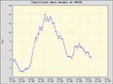
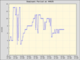
Overview: Low press. slides away from the region as high pressure moves in for the weekend and begining of next week. Behind it another, stronger Low will move across mid-week and set up some strong S/SSW windswell that will fade into the end of the week. Leftovers from the first Low pressure system will clean up for Sunday and a similar scenario will take place on Thursday.
Sun: 1-2' occ. 3' fading SSW(215) windswell, strongest east Wind:NW 25-30kts
Mon: <2' flat, minor traces Wind:S 10-15kts.
| Tue: | 2-3' SSW(197) quick windswell shot | Wind:S 15-20kts. G:30 |
| Wed: | 4-6' S(185) windswell develops | Wind:S 25-30kts. => SW |
| Thur/Fri/Sat: | 3-4'+=>2-3'=>1-2' S(187) windswell slowly fades. | Wind W => W => NE |
Updated:March 1st, 2008 @ 2100

 |
 |
 |
 |